A view of the Seine near our rowing club provides an alternate view of the rise of the Seine. Most of the photos of Paris show the impact near the iconic bridges, tow paths, and boats in the center of Paris.
Fille’s rowing club is on a part of the Seine near Saint-Ouen. It is a city in the northern suburbs, a bit gritty and not particularly picturesque, It is mostly known for being the home of a well-known flea market, Marché aux Puces de Saint-Ouen.
To see the impact on this part of the Seine, here are some images of the river. The one with the lower water level is from Wednesday (Jan 25) and the higher Friday (Jan27). You can see how more of the graffiti is covered (especially if you look at the word BEZAS).


And for comparison, this is how it looked in September.

Here are even more dramatic images showing the stairs and the dock this week.


Versus the regular level last September.

Even once the water levels start to recede, forecasters say it will be slow process, since much of the ground in northern France is already waterlogged. The December-January period has been one of the three rainiest since the beginning of the surveys in 1900, according to Météo-France.
Rowing on the Seine won’t resume for at least a month! And don’t forget the Bateaux Mouches aren’t able to get under the bridges and the quays are closed so they won’t be out on the river for a while either.
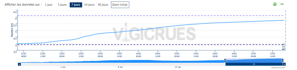
For a current update, here is the link to the french website monitoring the height of the river – Vigicrues. The graph from the website shows the increase in the water level over the past week. from about 4 meters to almost 6 meters. For comparison, just 30 days ago it was under 2 meters. Check out the website!